
Here is yet another piece of Eastern Kentucky farming history that I would like to share from the archives at Pine Mountain Settlement School in Harlan County…
CLEARING THE LAND
Planning for Pine Mountain was very deliberate and where land was involved, Katherine Pettit. co-founder of the School, was a keen observer and a diligent doer. Of the two co-founders, Pettit and Ethel de Long, it was Pettit who assumed the lead responsibility for the land issues of the School. Under Pettit’s direction, the land was to support the school, but it was also to be a driving force in the school’s programs. In her vision the land would be a source for the agricultural, educational, physical, and emotional needs of the school. The forests, gardens, planting fields, grazing fields, flower beds, —- all received careful consideration under her watchful eye. There is no doubt that the vision for the school’s physical site was always in Katherine Pettit’s mind’s eye but she also called on her excellent on-site help, particularly Uncle William Creech. If she didn’t find her answers in those close-by staff or in the community folk, she did not hesitate to seek outside consultation.
1913 opened with the first visit to the campus of one of the most important of those farm consultants, Miss Mary Rockwell, an architect from Kansas City, Together, Pettit, Ethel de Long, and Hook developed a plan for growth that centered on the topography of the land and the plan was followed, according to Evelyn Wells, (the first chronicler of the school’s history), very closely. Every effort was made to build around the productivity of the land; to use what the land provided and what the topography suggested. Forest lumber, stone from the fields, native plants and flowers, local human and animal labor, native seeds for garden crops and other native resources were called into use. All were considered important to the aesthetics and to the growth of the school and its environs. The remote location demanded that the planners seek local solutions to many of their needs and that they model the best solutions if they were to be both practical and educational in their mission. But, this local focus did not mean the outside world was excluded. It was, in fact, tapped for all it could contribute.
While Mary Rockwell Hook was helping to develop a plan for the land and how the buildings would interact with the landscape, several other consultants were also called upon for direct assistance with farming. James Adoniram Burgess, who was the Superintendent of Construction of buildings, a woodworker and vocational instructor at Berea College, starting in 1901, was well informed about construction and was heavily consulted by Pettit. Pettit also consulted with the Agricultural Department of State University (University of Kentucky), specifically J.H. Arnold, who had written extensively on factors necessary for a successful farm. While Arnold’s focus was on the Blue Grass area of the state he had some sound recommendations for the business side of agriculture. In 1917 he co-wrote with W.D. NIcholls, USDA Bulletin No. 210 “Important Factors for Successful Farming in the Blue Grass Region of Kentucky.” This unique partnering of Burgess and Arnold was evidently very productive. Ethel de Long notes in her May 1913 Letter to Friends, that the consultants
… were here last week … to give us their advice on the best use of our land and the best disposal of the buildings we hope to have in the course of time.
The progressive ideas of the early founders was not missed on visitors to the School. Margaret McCutchen, a visitor to the School in 1914 and writes:
“The first intimation I had of the School was the foot-log over Greasy, carefully flattened on top by well-placed stepping stones. Here I met with my second surprise, (the first was the beauty of the place) that about this school, only an infant in the wilderness, everything was so ship-shape. Good fences, substantial gates, roads, hitching posts, mounting blocks, the straight furrows of the ploughed fields and even rows of garden patches, wood-boxes on the porches, coat pegs by the doors, and the picturesque stone tool-house to protect the tools and farm implements — all these spell to me in large letters one of the chief articles in the constitution of the school, ORDER.”
View of the school grounds c. 1913-14. Old Log sits at what is now the entrance to the school. The foot-bridge Miss McCutcheon traversed is just opposite the cabin and crosses Isaac’s Creek where it becomes Greasy Creek, the headwaters of the great Kentucky River.
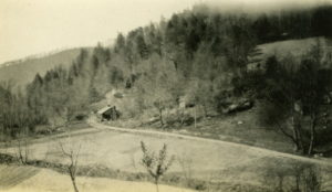
The school’s early years required some clearing of forested land and the re-preparation of older fields cleared by the earliest settlers. In the above view of one corner of the school campus, the land is just being prepared for farming. Efforts to straighten Isaac’s Creek [also known as Isaac’s Run] and to construct a bridge can be seen. Old Log cabin, the first permanent dwelling on the school grounds is seen to the left in the photograph. Moved to the site for early housing of staff, the structure still welcomes all who visit the school. Today it is the site of the school’s gift shop.]
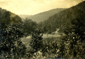
A very early view of the Pine Mountain Settlement. The distant house is Old Log with the “Indian Cliff” behind. The field in the foreground is in front of what is now the Chapel.
CREEK FARMERS
A view down the long Pine Mountain valley in the first decade of the twentieth-century would have revealed the steep hillside farming often practiced in the Pine Mountain valley and the surrounding valleys. In the narrow valleys such as that running beneath the long Pine Mountain spine, the community farmers used as much of their land as they were able to physically cultivate. Often the farms stretched far up the mountainside in a series of random terraces, often following natural contours of the land. The school claims to have introduced terracing but it was also introduced by livestock continually navigating the steep hillsides and by the constant planting and cultivating of corn rows that horizontally followed the contours of the hills. Each year the farmers often advanced up the mountain in search of rich soil as their crops depleted the soil. It was arduous work.
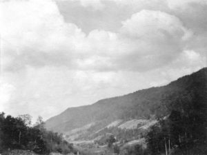
Looking from Uncle John’s toward the School.
While much farming in the Pine Mountain valley was on the sides of the mountain, the practice of farming in the area was often called “creek farming” and the farmers as “creek farmers.” The narrow strip of bottom land in the eastern Kentucky valleys led to this description in the 1960’s of those who farmed the region. The term was broadened to include the entire family and meant those families who lived only a stone’s throw from the streams of the region. In the small hollow that led into the valley, this geography was often accurate, but the broad slopes of the valley often meant that the farm was much more than a “stone’s throw” from the creek.
Because the developing transportation system often shared the same meandering creek path or sometimes the creek bed itself, the land that could be farmed was further reduced and families headed for the hills. This form of subsistence farming, a more common term than “creek farmers”, and the confined transportation corridors, led to the development in the valleys of a kind of continuous and uniformly distributed series of small “centers.” The so-called “Mouth of Big Laurel” is one such nuclear community. The Pine Mountain valley and most near-by valleys followed this pattern of development common to eastern Kentucky.
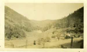
View of the Big Laurel Community in the second decade of the 20th century.
To learn more about early Appalachian farming practices visit the Pine Mountain Settlement School Archives.
Nice job. However, it feels like there is something that went before this article and something that comes after it. I’m hopeful that is true. I want to hear more about the school that is referenced and how it was designed in connection with the land and I want to know more about the people who had this vision and did this pioneering work.
Thanks and you are correct in your assumption. I have updated the post to include a link at the bottom to our archive website from which I extracted this snippet. The school’s history has provided me with much inspiration and guidance for our work today.
Thank you Preston for this lovely history of Pine Mountain Settlement School and farming in the mountains. PMSS is such a treasure!
Thanks Sue!